
Quay walls in the historic center of Amsterdam

The Municipality of Amsterdam faces the enormous task of assessing and potentially replacing 200 kilometers of quay walls along the charming old inner canals. Adjacent historic buildings are often vulnerable to damage from nearby construction activities. Satellite InSAR is used to monitor areas in the city. Monitoring shifts is seen as an essential tool to preserve the physical charm and historical heritage of this cityscape.
Deltares, the City of Amsterdam, TU Delft, and SkyGeo have published an article on the reliability of PS-INSAR usage compared to regular ground leveling and general InSAR data. The article describes how the PS-InSAR process can significantly shorten the current long period required for leveling updates and confirms the improved reliability when using a locally optimized SkyGeo InSAR dataset.
The City of Amsterdam began innovating centuries ago by applying leveling techniques with the introduction of the NAP (National Reference Height). Since then, markings have been applied to buildings throughout the city to estimate the degree of vertical displacement. This is a significant effort, given that the inner city is built entirely on soft ground. Both leveling and InSAR data are used throughout the city to gain valuable insights into vertical displacement. A direct comparison between leveling and satellite measurements reveals little, but researchers have developed a specific statistical procedure applied to both methods to verify their reliability and determine the degree of vertical displacement of buildings.
Persistent Scatterer SAR
The Persistent Scatterer (SAR) technique can measure object deformations very reliably. Satellites launched over the past decade produce raw data from which displacement time series can be obtained with high temporal and spatial resolution. Martijn Houtepen, InSAR Applications Expert at SkyGeo, was asked to provide two different datasets for the Amsterdam metropolitan area: a general dataset covering the entire city and a custom-made, locally optimized InSAR dataset. Three case studies were analyzed. The results showed coverage of nearly 100% for buildings in SkyGeo's locally optimized dataset. These structures all had reliable measurement points, far exceeding the results of general InSAR measurements and regular leveling.
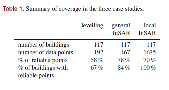
Conclusion of the PS-InSAR study
The results of this study support the way SkyGeo interacts with and advises customers. Gaining insight into local datasets through refinement is valuable. Caution is advised when using generic, publicly available InSAR datasets. All three case studies demonstrated that the displacement velocities of the satellite measurements are significantly higher than those of the leveling of the same buildings. Locally optimized PS-InSAR satellite measurements are best suited for assessing the displacement velocity of buildings in the Amsterdam city center. PS-InSAR is available to SkyGeo customers who wish to increase the reliability of InSAR data.
