GRONINGEN GAS FIELD CASE STUDY
InSAR FOR THE GRONINGEN GAS FIELD, NETHERLANDS - APPLICATIONS FOR INDUCED SEISMICITY
Since 2014, SkyGeo has been providing high-resolution InSAR monitoring over the Groningen province in the Netherlands. This asset’s production work has been correlated with Induced Seismicity and the field was shut in, in 2024. However, subsidence reporting requirements have remained and moreover, the field has so much geomechanical data available and is so well-studdied, that innovation keeps coming out of the team.
SkyGeo helps the asset’s business goals by routinely planning and executing InSAR time series analysis. During operation we used to provide monthly deformation updates to the customer (semi-continuous InSAR monitoring service), including:
decomposition into vertical/east-west deformation, extended to 3D - see below
advanced integration with 30+ GPS and levelling stations (a lot of work)
cross-checking and validation between TerraSAR-X results and other InSAR time series we provided (derived from RadarSat-2 and Sentinel-1 data),
full QC reports on the processing results according to Shell’s TS015 specifications.
We have also configured additional services, e.g. to:
Develop visualization tools and establish InSAR deliverable QC workflow to ensure data and process integrity, in which InSAR deliverables are used to influence business decisions.
Cross-validate InSAR deliverables, including horizontal deformation with the Groningen GNSS network,
Deliver prognostic study of surface deformation at the Norg gas storage based on InSAR and production data;
Advanced visualizations (movies, interactive maps, and reports, etc)
The ultimate objective of the project is to provide high-quality InSAR products for understanding the relationship between gas production and surface deformation as a result of compaction in the depleting reservoir and relaxation after shutdown.
In addition to services in Groningen, SkyGeo provides NAM with routine regional deformation monitoring services over the provinces of Twente and Zuid Holland. These data are integrated with the regional levelling and GPS network and are part of the long-term deformation monitoring plan by NAM.
The geomatics team in NAM is small but has world class domain expertise in applying InSAR to oil and gas production and we continue to evolve the knowledge together.
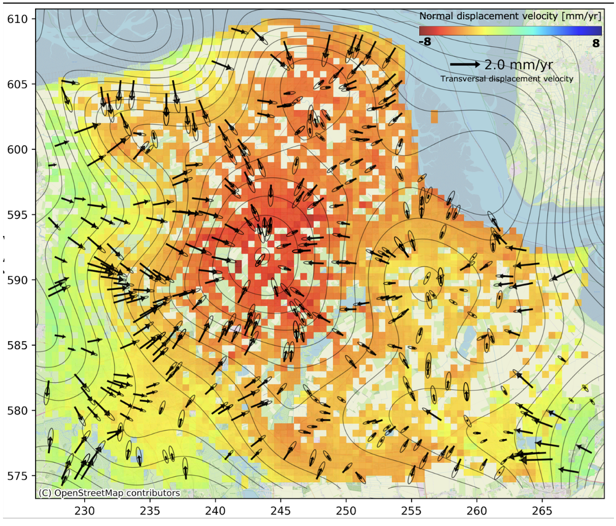
An exciting innovation we are taking in production is the deduction of local 2D, global 3D map. An example is shown for this field above. We deduce 3D motion and visualize it from InSAR data in vertical and East-West deformation direction. A simple 2D reservoir model is used to estimate N-S motion.
Oil & Gas Case Studies
-

Brunei Shell Petroleum
By monitoring both offshore platforms and onshore infrastructure with InSAR, Brunei Shell Petroleum can detect subtle deformation early and integrate these insights into geomechanical models and production decisions.
-
Berry
Using frequent InSAR monitoring, Berry can identify subsidence and uplift patterns across its fields, allowing engineers to fine-tune injection strategies and reduce the risk of well damage and environmental incidents.